
Betty doesn’t so much peer, as sneer, into the abrupt sheer walls of the Black Canyon (of the Gunnison). We hadn’t been to the North Rim of the Park before, until early October (2015). Yeah, like her — I was overcome by … Continue reading

Betty doesn’t so much peer, as sneer, into the abrupt sheer walls of the Black Canyon (of the Gunnison). We hadn’t been to the North Rim of the Park before, until early October (2015). Yeah, like her — I was overcome by … Continue reading

Above: “the Mesa” last winter. For my two or three (ir)regular readers, it’s pretty much THE VIEW from our house to the east. In later September, ‘fall’ was hitting the high country at full peak, so …

Betty decided that a trip up dere wuzz a good idea, to ride our bikes, get the dawgz out, and take lotsa photos. B ‘n “Doolie” on the Mesa-Top Trail.

We drove up Land’s End Road which is not the way to get up there for anyone in a hurry. The Road is ‘serpentine’ — winding, switchbacking, gravel with a good crop of washboards a lot of the time. The upper five or so miles it’s barely wider than a vehicle, so special caution is recommended there. However, today, we stopped frequently to try to capture the changing of the seasons, and the few other people we encountered were of similar dispostion.
We slowly gained in altitude. Above, we approach being level with the Mesa rim. The Grand Mesa is often called “the world’s largest flat-topped mountain.” Could be true. Geologists say that umpteen (25?) million years ago, there was a volcano 15,000-some feet higher than the present 10,000-foot plateau. A combination of the volcano blowing up and an outpouring of lava down to the valley floor resulted in the somewhat impermeable difficult-to-erode basaltic layer comprising the Mesa top today.

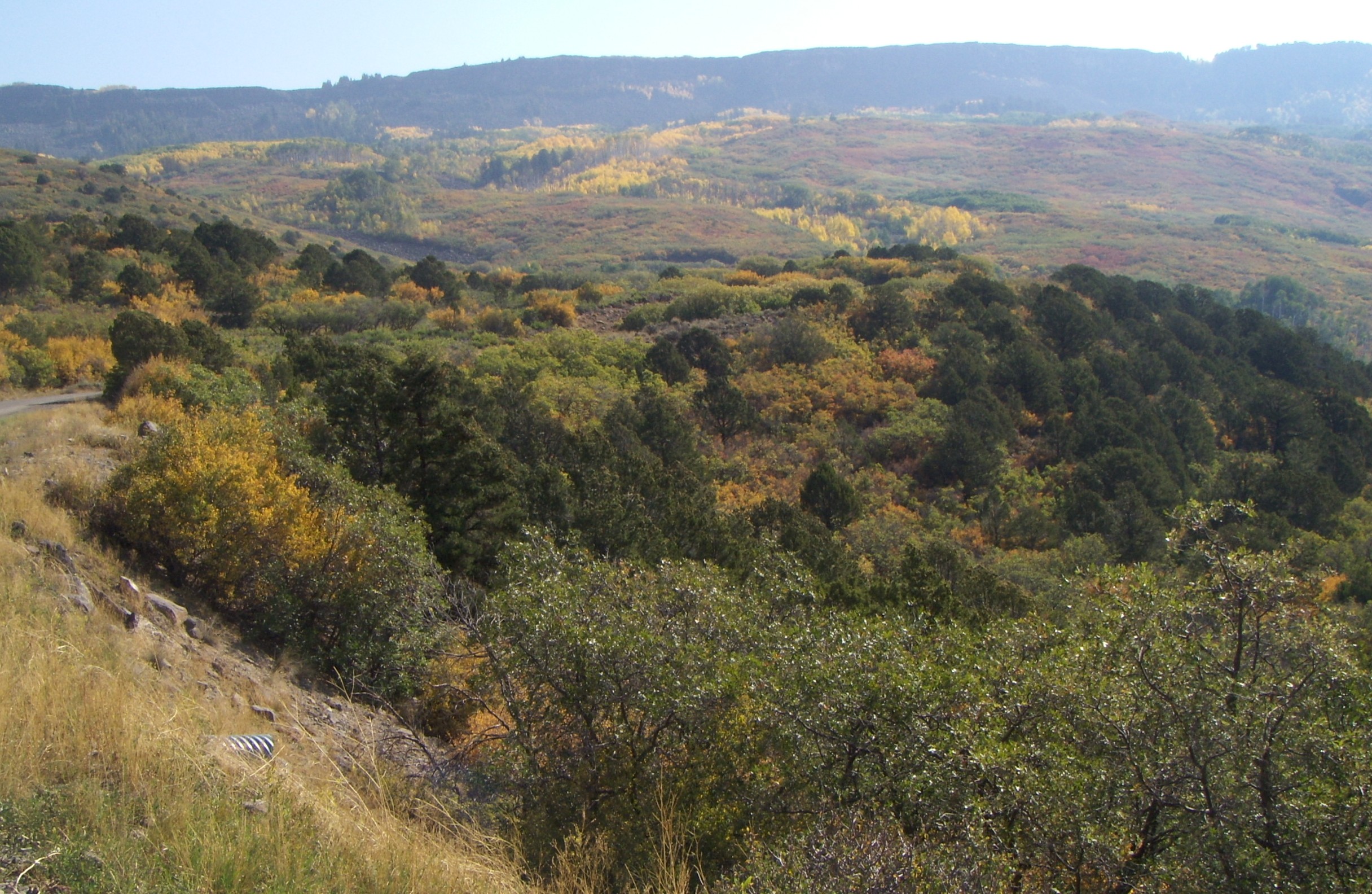
Looking down at what we’ve just driven up. The Mesa top is over 5,000 feet higher than the Grand Valley floor, our house included. What isn’t characteristic in this photo is the HAZE. Usually things are a lot clearer. There was a big forest fire up north in Wyoming, and the winds ‘n breezes must have been prevailingly nor’easters. So, we were afflicted with a much-more-so-than usual diminishment of clarity.
However, we discovered that the haze also diminished as we gained in altitude. The sky became clearer, blue skies, long as we didn’t look down the mountain. Still, you can tell that off the foot of the mountain the landscape is the ‘high desert’ of west Colorado. Also — if not for the haze, we would be able to see the LaSal Mountains just east of Moab — about 100 miles to the west.

Not all the aspens change at the same time. Generally, however, this is a function of altitude, and the higher we went, the larger percentage of trees had experienced “the change.” There was more red than we expected. I hope that is reflected in later photos.
I’ve backtracked in sequence a little. More haze, a couple thousand feet in elevation down from the top.

We are on top, the top of the world, looking south at the Flowing Park / Indian Point arm of the Mesa.

Above, is the view adjoining the previous. Dropping off into the haze, down to the desert. You might be able to recognize that a pine tree (fir, I think) towards the left in the far foreground (in front of the golden wall of aspens) is also pictured in the previous shot, towards the right.

I jump out of and back in sequence — this is perhaps 1,000′ or less in climb to go, with another darned section of washboards in the road.

Dually hangs close to Betty. The other two dawgz were (as usual) off harassing small creatures and/or looking for mud bogs to roll in.

I don’t know about you, but the zenith of the Autumnal Peak practically is shouting here. And I didn’t notice the contrail ’til later.

A few more colors in the palette used here — reddish, orange, yellow, green, the grey of the brief pavement section in this section of the Mesa.

Note (and memorize) the profile of the distant hazy ridge. You should recognize it again, further away, in the next photo.

Yes, we’ve stepped back from the previous view.

Back home, this bizarre fellow was clinging to our door. Stick-bugs might be abundant where you live, but for us, this is a more-rare sight than the more-common praying (preying?) mantises out our way.

On the other side of the door … we also recently lost (so we fear, it’s been several days now since we last saw him) the H P A (one of Walter’s other nick-names, the “Humongus Pongus Among us”). He was our favorite.

A typical vista for the day — just a bit down from the Mesa rim — with the trees framing the typical basalt cliff-face which, in turn, frames the Mesa top. The exposed cliff-rock is the edge of the foundation, as it were, of what makes the Grand Mesa what it is.
Summer’s here, as it is, presumably, almost everywhere north of the eeek!weightor. Day-time highs have been 100 (f). Good weather for forest fires …

The Pine Ridge fire, only about 10 miles north of our house. It was the largest (17k acres) in our area for quite some time. However, outside of the immediate region, it was un-noticed, due to its larger and more dangerous brethern elsewhere in the state.
We promised our dogs, who hadn’t been getting out much, that they would become DOGS OF THE FOREST. Sunday, July 1, we drove up Unaweep Canyon, turned off and up Divide Road, into the Dominguez (or Uncompahgre) Plateau.

Telephone Trail (near Dominguez Wilderness Area) crosses laFair Creek
We got out at the north head of Telephone Trail. No idea why its called that. It was still hot and dry where we were, but about 20 degrees cooler than at home. I thought we hiked down, along, then across the upper Dominguez Creek — but looked at a map later and we were in the LaFair Creek drainage (a tributary of the upper Dominguez). Challenging trail — posted for hikers and horses only. I suppose real ‘gonzo’ mountain bikers might have enjoyed it …

dogs of the forest, or of the rocks
The dogs appreciate being off-leash, out of the yard, and loose.

Betty’s hat & fir symmetry
Betty notices things I don’t. Like intricacies of flowers, insects, and the pattern of fir-tree branches.

more fir symmetry
Telephone Trail, once we made the steep and difficult-footing descent into LaFair Canyon, and the steeper climb out, actually becomes relatively level. We continued into the forest, lamenting occasionally that the area sure could use some rain.

Bruce is doing well
Meanwhile, back at home, Bruce is doing well. She (Betty insists Bruce is female) eats a pile of food seemingly equal to her body size every day during “eating season.”

inuksuit watches fire
The Pine Ridge fire burned for about a week. As you can see, the smoke resembles cumulus clouds once carried up high enough. And, we promised Rocksea, Sleven, and Dually that they’d be Dogs of The Forest again, soon.

cumulus growing fingers, near Cedaredge
Betty wanted to visit an art gallery, in search of works of a particular artist. On July 4th we drove to Cedaredge, to the Apple Shed Gallery, where she bought a silk screen, reminescent of the Oregon or Washington seacoast. (Artist’s name is mostly illegible — “Houksema”?) Cedaredge is logical as the first part of a Grand Mesa loop.

Island lake (regionally famous) on the whirled-faymuss Grand Mesa
From Cedaredge, we continued UP into (and onto) the Grand Mesa. What we wanted was a trailhead that wasn’t crowded. All the big reservoirs were miniature Coney Islands. Crag Crest Trail, where we had hoped to visit, was pretty popular also.

Lake RockSea Mirror
We stopped at the Mesa Top Trailhead. There were three other vehicles there. We had never heard of this before — and later, when I looked at maps, it must be ‘new’ as it wasn’t on any map I viewed. The Mesa, once you’re on top, is about as “relatively” level as you’re gonna be in the forest … or the glades …

mesa glade
The Mesa Top trail is a single-track, marked for hikers and mountain-bikes only. It was quite a change from “back home, down in the valley” as the temperature was maybe 70 and the area did not appear dry. In fact, it sprinkled, light rain, on us a few times.

rocksea, slevven
And yes, they were DOGS OF THE FOREST. On our way back we decided that the two younger dogs may have gone twice as far as we — what with the weaving back and forth, charging off into the trees, and, as often as possible, into the ponds and swamps.

flower yellow butterfly
As stated before, Betty notices things.

leaf green bug
(This was actually noticed on our Dominguez hike a few days before).

mesa glade, rain cloud

Betty pointed out the red, white, and blue flowers. Pretty appropriate for the day.

the dogs liked this!
This pond was about a mile from the trailhead. A pretty neat camping spot. Later, I found out from a fireman that what I thought was state-wide strict fire-restrictions was relaxed on the Mesa. We could have camped, with a fire.

Dually, cairns

lavender? flowerz

Sleven, amongst the cairns
We turned around at “the cairns” — about 2.5 miles from where we started. Good thing, the black dog has gotten so that this is “far” for him.

ladies of the forest
The ladies of the forest. Usually Rocksea is off and away, looking for small animals to torment. Or strange grunge to either roll in and/or eat.

(axually, this is from the previous hike, top (north) of LaFair Canyon)
We got back to the trailhead and talked to a couple who were looking at the billboard-map. They told us that further out on the same trail, they had seen a moose. I remarked that (1) I had NEVER seen a Colorado moose, and (2) our dogs would have, no doubt, run toward it, only to be CHASED AWAY.
We packed into the truck and completed the loop, through Mesa Lakes, Mesa (itself), and I-70 back home. It was 90+ degrees. The rest of the day, due to fireworks restrictions, was about as quiet a July 4th as there ever was. Oh, and the cat was apparently waiting for the mailman. (He must not have known that there’d be no mail delivery on July 4th.)

The post(wo)man hates this
Our mail delivery-person is sometimes harassed by the dogs. Now he (or she, when he is “off”) has a different problem …

Does he think the mailman has kitty treats?
