Mid June, dorgzeneye went further up Escalante Canyawn than i’ve ever been — above “the Forks.” Below, the dogs of the forest, or, of the high desert … One of the rare straight and open stretches of the road … Continue reading

Mid June, dorgzeneye went further up Escalante Canyawn than i’ve ever been — above “the Forks.” Below, the dogs of the forest, or, of the high desert … One of the rare straight and open stretches of the road … Continue reading

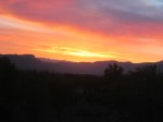
Last weekend I visited Carson Lake, at the top of the Kannah Creek drainage off the Grand Mesa (west Colorado). Weird, from my house I look out at the general vista encompassing the Lake practically every day and this was … Continue reading
Summer’s here, as it is, presumably, almost everywhere north of the eeek!weightor. Day-time highs have been 100 (f). Good weather for forest fires …

The Pine Ridge fire, only about 10 miles north of our house. It was the largest (17k acres) in our area for quite some time. However, outside of the immediate region, it was un-noticed, due to its larger and more dangerous brethern elsewhere in the state.
We promised our dogs, who hadn’t been getting out much, that they would become DOGS OF THE FOREST. Sunday, July 1, we drove up Unaweep Canyon, turned off and up Divide Road, into the Dominguez (or Uncompahgre) Plateau.

Telephone Trail (near Dominguez Wilderness Area) crosses laFair Creek
We got out at the north head of Telephone Trail. No idea why its called that. It was still hot and dry where we were, but about 20 degrees cooler than at home. I thought we hiked down, along, then across the upper Dominguez Creek — but looked at a map later and we were in the LaFair Creek drainage (a tributary of the upper Dominguez). Challenging trail — posted for hikers and horses only. I suppose real ‘gonzo’ mountain bikers might have enjoyed it …

dogs of the forest, or of the rocks
The dogs appreciate being off-leash, out of the yard, and loose.

Betty’s hat & fir symmetry
Betty notices things I don’t. Like intricacies of flowers, insects, and the pattern of fir-tree branches.

more fir symmetry
Telephone Trail, once we made the steep and difficult-footing descent into LaFair Canyon, and the steeper climb out, actually becomes relatively level. We continued into the forest, lamenting occasionally that the area sure could use some rain.

Bruce is doing well
Meanwhile, back at home, Bruce is doing well. She (Betty insists Bruce is female) eats a pile of food seemingly equal to her body size every day during “eating season.”

inuksuit watches fire
The Pine Ridge fire burned for about a week. As you can see, the smoke resembles cumulus clouds once carried up high enough. And, we promised Rocksea, Sleven, and Dually that they’d be Dogs of The Forest again, soon.

cumulus growing fingers, near Cedaredge
Betty wanted to visit an art gallery, in search of works of a particular artist. On July 4th we drove to Cedaredge, to the Apple Shed Gallery, where she bought a silk screen, reminescent of the Oregon or Washington seacoast. (Artist’s name is mostly illegible — “Houksema”?) Cedaredge is logical as the first part of a Grand Mesa loop.

Island lake (regionally famous) on the whirled-faymuss Grand Mesa
From Cedaredge, we continued UP into (and onto) the Grand Mesa. What we wanted was a trailhead that wasn’t crowded. All the big reservoirs were miniature Coney Islands. Crag Crest Trail, where we had hoped to visit, was pretty popular also.

Lake RockSea Mirror
We stopped at the Mesa Top Trailhead. There were three other vehicles there. We had never heard of this before — and later, when I looked at maps, it must be ‘new’ as it wasn’t on any map I viewed. The Mesa, once you’re on top, is about as “relatively” level as you’re gonna be in the forest … or the glades …

mesa glade
The Mesa Top trail is a single-track, marked for hikers and mountain-bikes only. It was quite a change from “back home, down in the valley” as the temperature was maybe 70 and the area did not appear dry. In fact, it sprinkled, light rain, on us a few times.

rocksea, slevven
And yes, they were DOGS OF THE FOREST. On our way back we decided that the two younger dogs may have gone twice as far as we — what with the weaving back and forth, charging off into the trees, and, as often as possible, into the ponds and swamps.

flower yellow butterfly
As stated before, Betty notices things.

leaf green bug
(This was actually noticed on our Dominguez hike a few days before).

mesa glade, rain cloud

Betty pointed out the red, white, and blue flowers. Pretty appropriate for the day.

the dogs liked this!
This pond was about a mile from the trailhead. A pretty neat camping spot. Later, I found out from a fireman that what I thought was state-wide strict fire-restrictions was relaxed on the Mesa. We could have camped, with a fire.

Dually, cairns

lavender? flowerz

Sleven, amongst the cairns
We turned around at “the cairns” — about 2.5 miles from where we started. Good thing, the black dog has gotten so that this is “far” for him.

ladies of the forest
The ladies of the forest. Usually Rocksea is off and away, looking for small animals to torment. Or strange grunge to either roll in and/or eat.

(axually, this is from the previous hike, top (north) of LaFair Canyon)
We got back to the trailhead and talked to a couple who were looking at the billboard-map. They told us that further out on the same trail, they had seen a moose. I remarked that (1) I had NEVER seen a Colorado moose, and (2) our dogs would have, no doubt, run toward it, only to be CHASED AWAY.
We packed into the truck and completed the loop, through Mesa Lakes, Mesa (itself), and I-70 back home. It was 90+ degrees. The rest of the day, due to fireworks restrictions, was about as quiet a July 4th as there ever was. Oh, and the cat was apparently waiting for the mailman. (He must not have known that there’d be no mail delivery on July 4th.)

The post(wo)man hates this
Our mail delivery-person is sometimes harassed by the dogs. Now he (or she, when he is “off”) has a different problem …

Does he think the mailman has kitty treats?
